In former times, there used to be no GPS. Now we need you to find the exact geographic location of historical images! We launched the innovative georeferencing platform sMapshot (general homepage) at our second crowdsourcing meeting on 30 January 2018 (see also the video recording). Dive right into our collection at https://smapshot.heig-vd.ch/ethz.
What’s sMapshot?
sMapshot is a platform for local participants to position and geolocalise historical images on a virtual globe. The virtual globe is based on the latest satellite images and Swisstopo’s 3D buildings. Bing Maps is available as an option for photographs looking across the border. sMapshot is a project conducted by the Laboratoire de SIG, Haute École d’ingénierie et de gestion du canton de Vaud (HEIG-VD).
Why georeferencing?
The primary goal of our crowdsourcing is to improve metadata in general. Whether this be by commenting on E-Pics Image Archive Online, as has been and will continue to be possible on all images, or via the new sMapshot tool. Georeferencing and geolocalising on sMapshot improves the following metadata:
- Calculating camera position, line of vision and height from which photograph was taken
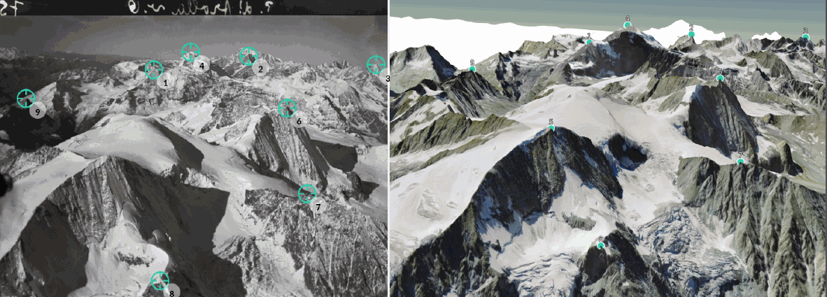
- Calculating all place names visible in the picture (places, rivers, fields, mountains etc.)
- Calculating “footprints”
More specifically, this means you no longer have to painstakingly write down all the names of the peaks in a depicted mountain range in the E-Pics comments function. sMapshot now does this for you!
This makes our images even more of a “goldmine for academia”. After all, these exact geographic coordinates enable the following analyses to be made, for example:
- Calculating glacial recession and natural hazards
- Analysing urban development (e.g. the influence of infrastructure)
- Reconstructing vanished historical buildings virtually
How does sMapshot work? Tips & tricks
For starters: the learning curve is very steep! Just wait and see: after a few images, you’ll already have got the hang of it!
General
- Please sign up to manage your images in mySmapshot and feature on the leaderboard. You can register via Facebook, Google plus or a separate log-in.
- Preferably work with modern browsers such as Chrome, Firefox or Edge. In principle, it is also possible to work with the latest versions of Internet Explorer and Safari.
- Before you can georeference the first image, you will be shown a one-off tutorial video. Provided you are registered, this will no longer appear for the second image.
- The virtual globe is by Swisstopo and only covers Swiss territory. Activate Bing Maps to display landscapes abroad in border regions.
Georeferencing
- Geolocalisation takes places in two steps:
- Firstly, you have to specify at least four points that correspond to each other on the image and the virtual globe. This enables the image to be roughly located.
- You will then be asked to specify at least two other points so the image can be geolocalised in full.
- Spread the points over the entire image to cover as wide an area as possible. This enables the image to be inserted in the virtual global with precision.
- Place reference points on the landscape! For buildings, place the points on the foundations (i.e. in the landscape) and not on the buildings as these will not be recognised and the points will be assessed as “wrong”.

Improve
- If points are not or not exactly displayed (orange or red), they can be selected/activated with the mouse and moved.
- Try the following, too: place another point, recalculate the image, delete the points placed previously if need be, then recalculate the image again. This may help if the localisation is not yet exactly spot-on.
- Pay particular attention to the continuation of roads from the image edges into the virtual globe. For mountain peaks and ranges, you will also soon see whether the localisation is accurate when you superimpose the image in the virtual globe and simultaneously check the localisation with the slide bars “depth” and “transparency”.
- If you find that a picture appears as a mirror image and you are thus unable to geolocalise it, you can report this under “report a problem” (underneath the image).
Additional features
- From Monday 12 February 2018, you will also be able to signal corrections for titles and descriptions directly in sMapshot However, please only indicate substantial corrections, such as erroneous place or mountain names. Don’t send us any additions! This is unlike commenting on E-Pics Image Archive Online, where you give descriptions of objects in the foreground, for instance. Examples of corrections:
- Rebstein, Jacob Rohner AG textiles company. The image depicts the Rohner sock factory, which is actually in the neighbouring village of Balgach, not Rebstein.
- Mönch with Jungfrau, fuselage in the photograph from side from 4,500 m. The corrected version: Mönch with Eiger (just visible in the background), which is not quite the same! 180° view.
- We will make the corrections directly in the Bildarchiv Online image database, not in sMapshot. So don’t look for the corrections in sMapshot!
- From Monday 12 February 2018, the notes function will also be online. You can use this feature to highlight something in a historical image and leave a note if you would like to point out a particularly noteworthy detail, for example.
Validation of the images by the Image Archive team
After you have successfully localised an image, we check and validate it. Like with the comments, we do this very swiftly, i.e. within one to three working days. We check how accurately the image fits into the virtual globe. If it is good, we approve the image. If you work with a log-in, you will then receive another point on the leaderboard. We may also make minor corrections. After only a few days, however, we have already noticed that this can be very time-consuming and that it makes more sense to reject an image. You can then try again. If you work with a log-in, you can manage our validation steps in the mySmapshot section.
What’s mySmapshot?
The mySmapshot section is for participants who have registered with their own username. On the left-hand side, you will see navigation icons. These are the following sections, from top to bottom:
- My settings: here, you can change your username and set the language, for instance.
- The three sections “My georeferencing/My suggestions/My notes have the following filter functions:
Owners: Filter by owning institution. sMapshot is a collaborative platform, i.e. other institutions are also represented on it.
Collections: unlike on E-Pics Bildarchiv Online, the images are not all placed online. Instead, we work with collections and campaigns. The Walter Mittelholzer aerial photograph campaign is currently underway.
Status: here, you can enquire whether an image is still on the waiting list with us, or has been confirmed, corrected or rejected. You can reactivate and reprocess rejected images.
Filter by date
- My georeferences: Here, you see the status of your georeferenced images. Every image is checked by us and, if need be, corrected, approved or rejected. The various statuses are displayed using the following colours:
- The first image has been confirmed. There is a green tick at the top right.

- The second image has been corrected. There is an orange tick at the top right. We explain the reason for the improvement in the red speech bubble.

- The third image has been rejected. There is a red cross at the top right. Once again, the explanation is given in the red speech bubble. Click on the curved arrow at the bottom right. This relaunches the image for a second attempt.

- My ranking: here, you can display the statistics by month and year. A filter for “all” under month so you can display the entire year is in the pipeline.
- My suggestions: here, you can view the status of your suggested corrections for titles and descriptions.
- My notes: here, you can view the status of your notes.
Ongoing and scheduled campaigns.
You have been beavering away for more than a week now! And you have achieved so much! The developers can hardly believe their eyes! The day before yesterday, by Monday lunchtime, the first 2,000 images had already been referenced. The current leaderboard is displayed on the sMapshot homepage.
sMapshot works in campaigns.
- We kicked things off with the roughly 12,000 aerial photographs of Switzerland by Walter Mittelholzer. You can find our collection here.
- We will shortly be launching a mini-campaign on floods. You have already dealt with the bad weather in Gürbetal; we will also have these images georeferenced. We were asked by the University of Bern and the Mobiliar Lab for Natural Risks here. Before we can provide our images for academic purposes on our new platform, they need to be georeferenced. The new Mobiliar Lab platform will be launched in May 2018. More information on this will follow in this blog.
- Other topics: Glacier photographs from the Glaciological Commission and the 20,000 aerial photographs by Werner Friedli, which he took for Swissair Photo as Mittelholzer’s successor.
What does this mean for you?
- Commenting on E-Pics Bildarchiv Online is still possible and welcomed. New images will be presented here on the blog every Monday.
- You can also georeference selected images via sMapshot. As a result, there is no need for certain comments on E-Pics Bildarchiv Online.
- We are running the statistics separately for the time being. For the text comments on E-Pics Bildarchiv Online, you will find the statistics here on the blog and for sMapshot on the homepage or your mySmapshot.
If you spot any mistakes on the platform, you can report them. Send an email to nicole.graf@library.ethz.ch.
sMapshot is a tool that could become highly addictive!
What I keep hearing from the extensive feedback: great tool but really additive! It’s like a game! It can have a huge impact on your free time! 😉
DOI Link: https://doi.org/10.35016/ethz-cs-4995-en

[…] Weitere Informationen auf der Webseite der ETHZ: Link […]